
Help Us Bypass Censorship. Share This.
Sign up to receive Our Weekly Briefing Newsletter
Begin your journey with weekly insights designed to expand awareness and ground you in truth. Our free tier gives you a powerful introduction without any commitment.
No continent on Earth is more tightly controlled, more visited by heads of state, and less reported on than Antarctica. In the span of three weeks in late 2016, three figures made separate, largely unexplained journeys to the continent: U.S. Secretary of State John Kerry – the highest-ranking American government official ever to visit Antarctica, according to the New York Times – flew there on Election Day, when the eyes of the world were elsewhere. Russian Orthodox Patriarch Kirill visited a Russian Antarctic outpost, officially to see penguins. Buzz Aldrin, the Apollo 11 astronaut, traveled to the South Pole with a tourist group – and was medically evacuated within hours of arrival.
None gave full public accounts of what they saw. None were accompanied by press pools. The timing was, at minimum, unusual.
The Antarctica hidden secrets conversation is not built on that coincidence alone. It is built on a convergence of documented anomalies that researchers, cartographers, geologists, and former military officials have been assembling for decades: a 500-year-old map that appears to show an ice-free Antarctic coastline, a massive U.S. Navy expedition that ended abruptly and without explanation, a subglacial continent of hidden lakes, rivers, and ancient preserved landscapes that mainstream science is only now beginning to map, and a governance structure that formally restricts what can be done, built, or disclosed on the most isolated landmass on Earth.
This article presents the documented record in full – geological explanations alongside the anomalies, mainstream assessments alongside the researcher claims. We present. You decide.
For the broader context of suppressed ancient history, see the GAR Forbidden History archive.
The Piri Reis Map: Antarctica Hidden Secrets Begin in 1513
The map exists. The debate about what it shows is documented, serious, and unresolved.
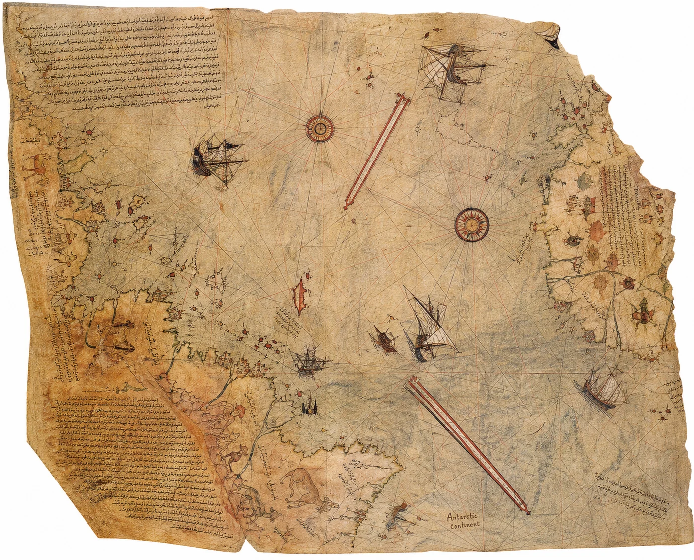
The Piri Reis map is a genuine historical document – a world map compiled in 1513 by Ottoman admiral and cartographer Piri Reis, rediscovered in the Topkapi Palace museum in Istanbul in 1929. It is one of the earliest known maps to show the Americas, and approximately one third of the original survives. It is housed, studied, and accepted as authentic by mainstream cartographic scholars.
The controversy begins in the map’s southern section. In 1960, Professor Charles Hapgood of Keene College – a respected academic whose research was endorsed in its foreword by President Eisenhower’s personal friend Albert Einstein – wrote to the U.S. Air Force requesting a formal cartographic evaluation of the map’s southern landmass, which he argued depicted the coastline of Antarctica as it would appear without its ice cover.
On July 6, 1960, Colonel Harold Z. Ohlmeyer of the 8th Reconnaissance Technical Squadron at Westover Air Force Base responded. His letter, quoted in Hapgood’s subsequent work and documented in the Wikipedia record on Hapgood’s career, states: “The claim that the lower part of the map portrays the Princess Martha Coast of Queen Maud Land, Antarctica, and the Palmer Peninsula, is reasonable. We find this difficult to explain… the geographic detail shown in the lower part of the map agrees very remarkably with the results of the seismic profile made across the top of the ice-cap by the Swedish-British-Norwegian Antarctic Expedition of 1949.”
The U.S. Air Force, in an official letter, acknowledged that a 1513 map appeared to accurately depict the sub-ice topography of Antarctica – topography that was not confirmed by modern science until seismic surveys conducted in 1949. Antarctica itself was not even reached by Western explorers until 1820, more than three centuries after the map was drawn.
Hapgood published his full analysis in Maps of the Ancient Sea Kings (1966), arguing that the map’s accuracy implied the existence of an advanced ancient civilization capable of sophisticated cartography – one that surveyed Antarctica before the continent was covered in ice.
The mainstream counterargument, presented with equal honesty: cartographic scholars including researchers at the University of Canterbury have argued that the southern landmass on the Piri Reis map is better explained as a distorted depiction of South America, reflecting the incomplete geographic knowledge of the era. Piri Reis’s own handwritten notes on the map, per a 2025 Zenodo cartographic analysis, reference source maps from Columbus’s voyages – not unknown ancient sources. The debate is not settled. But Colonel Ohlmeyer’s letter is real, documented, and never satisfactorily answered by the mainstream.
A 1513 Ottoman map that may – or may not – depict an ice-free Antarctic coastline. The U.S. Air Force found it “difficult to explain.” So do we.
Operation Highjump Antarctica: The Mission That Ended Too Soon
The largest military expedition in Antarctic history was terminated early, without full public explanation.
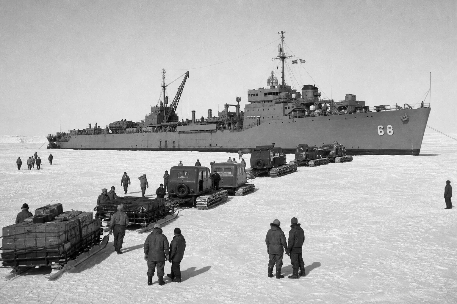
In 1946, the United States Navy launched Operation Highjump – officially the “U.S. Navy Antarctic Developments Project” – under Rear Admiral Richard E. Byrd. The operation was the largest Antarctic expedition in history at the time: 4,700 men, 13 ships, and 33 aircraft, organized as a full military task force. The stated objectives, per official Navy records archived at the Ohio State University Byrd Polar Research Center and declassified CIA documents, included establishing Antarctic bases, training personnel, and testing equipment under polar conditions.
The expedition was planned for six to eight months. It was terminated after approximately eight weeks.
No complete official explanation for the early termination was ever released to the public. Navy records cite “weather conditions” as a contributing factor. The National Archives blog on Operation Highjump acknowledges the expedition’s abrupt conclusion without elaborating on its causes. The CIA’s own declassified document on Antarctic operations provides a factual summary of Byrd’s role without addressing the termination circumstances.
What is documented: Admiral Byrd, upon return, gave a press interview to Chilean newspaper El Mercurio in which he reportedly warned of a potential threat from “enemy aircraft” capable of flying “from pole to pole at incredible speeds.” The original interview is difficult to verify in its full text through institutional sources, and the quote has been distorted in retellings – a fact GAR notes clearly. What is not disputed: Byrd was a four-star admiral, a decorated explorer, and the most experienced Antarctic expedition leader in American history. The expedition he commanded was cut dramatically short.
The alternative interpretation – advanced by researchers in the Disclosure Files community – is that Highjump encountered something in Antarctica that prompted an immediate withdrawal and a subsequent classification of findings. The documented interpretation is that weather, logistics, and shifting Cold War priorities curtailed the mission. Both exist in the record. The full record does not.
The Antarctica Pyramids: What Geologists Say – and What They Don’t Explain
The formations are real. The question is whether geology fully accounts for them.
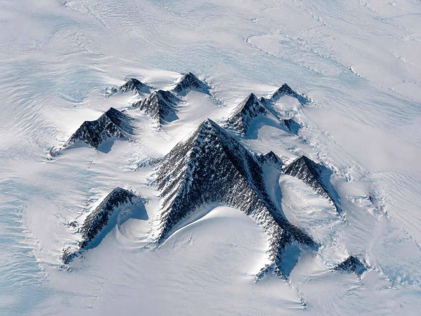
The Antarctica pyramids controversy began in earnest in 2012 when satellite imagery revealed what appeared to be several strikingly symmetrical, four-sided pyramid-shaped formations in the Ellsworth Mountains of Antarctica. The images spread globally. The response from mainstream science was swift and consistent: these are nunataks – peaks of rock that protrude above glacial ice, shaped over millions of years by freeze-thaw erosion and glacial action into angular, sometimes geometrically regular forms. Science Feedback’s peer-reviewed assessment confirms this explanation clearly, and LiveScience’s geological analysis notes the formation is approximately 4,150 feet tall – consistent with natural mountain scale.
The nunatak explanation is geologically sound and should be stated clearly: the Antarctica pyramid formations visible in satellite imagery are, by the best available geological evidence, natural. Glacial erosion produces pyramidal peaks on every glaciated continent. This is not contested terrain in geology.
What is less discussed: the same satellite and radar surveys that debunked the pyramids as man-made have revealed, beneath Antarctica’s ice, a hidden landscape of extraordinary complexity – ancient river valleys, mountain ranges, plains, and canyon systems that predated glaciation. A 2023 study published in Nature Communications documented a preserved ancient river landscape in East Antarctica, sealed beneath the ice sheet for millions of years, showing a terrain “at odds with the modern ice configuration.” A January 2026 Smithsonian Magazine report described a new Science journal map of Antarctica’s entire subglacial terrain – mountains, canyons, valleys, and plains – that had been completely unknown before modern radar mapping.
Antarctica before glaciation was not a barren wasteland. It was a temperate continent with rivers, lakes, and – according to peer-reviewed geological evidence in Science (2024) – conditions in West Antarctica during the early Oligocene that were cool-temperate, with mild ocean and air temperatures, forested coastlines, and no ice sheet.
Not pyramids built by humans. But a continent that was habitable – and complex – long before the ice arrived. The implications of what may have existed on that terrain remain open.
Antarctica Underground Structures: The Subglacial World Science Is Mapping
The hidden world beneath Antarctica’s ice is real, documented, and stranger than most coverage acknowledges.
As of the most recent scientific surveys, Antarctica contains 675 known subglacial lakes, according to Wikipedia’s Lake Vostok article, which itself is sourced from peer-reviewed glaciology literature. The largest, Lake Vostok, sits beneath nearly 4 kilometers of ice and is approximately the size of Lake Ontario. Russian scientists drilled through to it in 2012, according to Columbia University’s Lamont-Doherty Earth Observatory – and the initial water samples they recovered were never fully published in peer-reviewed literature, a gap that researchers have noted without mainstream explanation.
In 2025, National Geographic reported on a decade-long radar mapping project that revealed entire river systems flowing beneath Antarctica’s ice – rivers that flow uphill in places, fed by geothermal heat, creating vast subglacial drainage networks invisible from the surface. The same radar surveys have revealed subglacial lake systems interconnected by channels, some of which drain and refill cyclically, creating a dynamic underground hydrological system that scientists are still working to map.
In March 2026, NASA’s Earth Observatory published findings on Lake Unter-See in Antarctica – a sealed subglacial lake with highly unusual water chemistry and cone-shaped microbial structures with no known modern analog. NASA described it as one of the only lakes of its kind on Earth.
These are not fringe claims. They are NASA, National Geographic, Nature, and Science journal findings published within the past three years. What they collectively describe is a continent whose subglacial world is vastly more complex, geologically active, and biologically rich than the public image of a featureless ice sheet implies.
The Antarctica underground structures claim – that geometrically anomalous features exist beneath the ice that are not adequately explained by natural geology – remains in the researcher claim category. What is confirmed is that there is an enormous, poorly understood hidden world beneath Antarctica’s ice that is only now being mapped, and that the most conservative mainstream findings are extraordinary enough to warrant serious attention.
The Ancient Map of Antarctica and the Lost Civilization Question
If the Piri Reis map depicts Antarctica, someone surveyed it before the ice. That implication cannot be dismissed casually.
The mainstream position on the ancient map of Antarctica claim is that the Piri Reis southern landmass is a distorted South America, assembled from Columbus-era sources, and that the similarities to Antarctica’s sub-ice coastline are coincidental or forced by selective comparison.
The alternative position – advanced by Hapgood, later by Graham Hancock in Fingerprints of the Gods (1995), and by researchers in the forbidden history and disclosure community – is that the accuracy of the sub-ice coastline match, confirmed in writing by the U.S. Air Force in 1960, implies the existence of a pre-glacial civilization capable of systematic cartography. Hapgood specifically proposed that Antarctica was last free of significant ice approximately 6,000 years ago – a figure now generally not supported by mainstream glaciology, which places the last major Antarctic glaciation beginning approximately 34 million years ago, with partial deglaciation periods at much smaller scales.
This is where the honest investigative posture requires precision. The geological record, per peer-reviewed research in Science (2024), confirms that Antarctica has had periods of significantly reduced glaciation in deep geological time – but the timescale is millions of years, not thousands. The gap between what the Hapgood hypothesis requires (a habitable Antarctica accessible to human civilization) and what the geological consensus supports is significant and should be stated.
What cannot be dismissed: the Piri Reis map is real, the Air Force evaluation is documented, and the sub-ice topography match that Ohlmeyer described was confirmed against seismic surveys decades after the map was drawn. Whether this reflects advanced ancient cartography, a remarkable coincidence, or something yet to be adequately explained is a question the mainstream has not answered to the satisfaction of serious researchers.
For our full investigation into the forbidden history of ancient civilizations, see the Forbidden History archive, including our reports on Atlantis and the Anunnaki.
Antarctica Discoveries Covered Up: The Governance Architecture
The framework that controls Antarctica is real, formal, and extraordinarily comprehensive.
The Antarctic Treaty of 1959, signed by twelve nations and now comprising 56 signatories, established Antarctica as a continent reserved for peaceful scientific research. It prohibits military activity, nuclear testing, and sovereign territorial claims. On its face, it is a landmark international agreement.
What it also creates – less discussed – is a governance structure that concentrates access and decision-making authority in a small number of state parties. Under the treaty framework, only Consultative Parties (currently 29 nations) have full decision-making authority. The treaty requires unanimous consent for significant policy changes. Independent researchers, journalists, and private citizens face substantial practical barriers to accessing most of Antarctica – not because of formal prohibition of civilian access, but because the physical and logistical requirements for Antarctic travel effectively restrict it to state-sponsored expeditions, approved scientific programs, and a small number of licensed operators.
The result: Antarctica is the only continent on Earth where what is found, what is reported, and what is disclosed is almost entirely mediated through government and institutional channels. There is no independent press corps in Antarctica. There are no civilian witnesses to routine scientific operations at the continent’s interior stations. Findings pass through institutional review before public release.
This is not evidence of a conspiracy. It is a description of the governance structure – one that would be ideally designed to manage disclosure, if disclosure management were the goal.
Forbidden History Antarctica: The Pattern the Evidence Describes
No single piece of evidence here proves what the disclosure community claims. The pattern is another matter.
The forbidden history Antarctica framework – the claim that an advanced ancient civilization existed on the continent before glaciation, that evidence of it has been found by modern expeditions, and that the findings are being suppressed by the same institutional architecture that controls Antarctic access – is, in its strongest form, a researcher interpretation rather than a confirmed fact.
What is confirmed, in the documented record:
- A 1513 map that the U.S. Air Force found difficult to explain, depicting what may be Antarctica’s sub-ice coastline
- The largest military Antarctic expedition in history, terminated early with no fully documented explanation
- A continent with 675+ known subglacial lakes, hidden river systems, and ancient preserved landscapes mapped only in the past three years
- Geological evidence that Antarctica was ice-free, temperate, and biologically productive in deep geological time
- A governance framework that concentrates control of Antarctic access and disclosure in state institutions
- Three high-profile 2016 visits by a U.S. Secretary of State, a Russian religious leader, and an Apollo astronaut – none publicly explained in full
Each of these facts has a conventional explanation. The Piri Reis southern landmass may be South America. Highjump may have ended for logistical reasons. The subglacial lakes are the product of geothermal activity. The ancient landscape is millions of years old. The treaty is a genuine peace agreement. The 2016 visits were about climate change and scientific diplomacy.
These conventional explanations may be correct. The GAR standard is not to dismiss them – it is to note that the pattern they collectively form is unusual enough to warrant the question, and that the institutional structure that would be required to suppress significant findings from Antarctica already exists and functions precisely as described.
What Comes Next: Disclosure and the Antarctic Timeline
The ice is melting. What it reveals will not be containable indefinitely.
The most significant development in the Antarctica hidden secrets conversation is not a new expedition or a leaked document. It is the ice itself. Climate change – whatever its causes – is accelerating Antarctic melt at a rate that is producing new exposures of sub-ice terrain that has been sealed for geological timeframes. A January 2026 Reuters report on the new Science journal Antarctic terrain map notes that the subglacial landscape now being revealed includes features – canyons, mountain ranges, and plains – that have never been seen by human eyes in recorded history.
What those landscapes contain, what those lakes hold, and what the ancient preserved terrain in East Antarctica – sealed for millions of years, per the 2023 Nature Communications study – looked like before the ice arrived, is no longer purely a matter of speculation. It is an active scientific frontier, moving faster than any previous Antarctic research period, producing findings that are genuinely extraordinary on their own terms.
The disclosure community’s claim – that what is found will rewrite human history – may or may not be correct in the form it is typically stated. What is certain: Antarctica is yielding information, at an accelerating rate, that the existing framework of human history does not yet fully account for. The honest response is not certainty in either direction. It is sustained, evidenced attention.
The ice does not keep secrets forever. It keeps them until the conditions change. The conditions are changing.
For related investigations, see GAR’s reporting on Disclosure Files, the Great Awakening movement overview, and the full Forbidden History archive.
The full Forbidden History archive – including deep-dive reports on Antarctica ancient civilizations, the Piri Reis map, Operation Highjump, subglacial discoveries, and the broader disclosure timeline – is available to Standard and Premium subscribers at the Great Awakening Report. Join 99,000+ truth seekers here →
Sign up to receive Our Weekly Briefing Newsletter
Begin your journey with weekly insights designed to expand awareness and ground you in truth. Our free tier gives you a powerful introduction without any commitment.


Help Us Bypass Censorship. Share This.
Have questions?
At Great Awakening Report, we are dedicated to supporting your journey toward truth and enlightenment through our specialized Coaching and Consulting services.
Coaching Services: Our coaching programs are designed to guide you through personal awakening and transformation. We offer personalized sessions that focus on expanding consciousness, uncovering hidden truths, and fostering spiritual growth. Our experienced coaches provide the tools and insights necessary to navigate your path with clarity and confidence.
Consulting Services: For organizations and individuals seeking deeper understanding and strategic guidance, our consulting services offer expert analysis and solutions. We delve into areas such as global transitions, alternative news insights, and consciousness studies to provide comprehensive strategies tailored to your unique objectives.
Embark on a transformative journey with our Coaching and Consulting services, and unlock your highest potential. To learn more and schedule a session, visit our Coaching and Consulting pages.
Thank you
Thank you to our subscribers and readers for your continued support and dedication to truth and awakening. Your encouragement, engagement, and belief in our mission make everything we do possible. Together, we are expanding awareness and helping illuminate the path forward.
If you would like to further support the Great Awakening team and our ongoing efforts to share insight, knowledge, and truth, you can DONATE HERE.
With deep gratitude,
– Great Awakening Team
About the Author: Great Awakening Team
DISCLAIMER: All statements, claims, views and opinions that appear anywhere on this site, whether stated as theories or absolute facts, are always presented by The Great Awakening Report (GAR) as unverified—and should be personally fact checked and discerned by you, the reader.Any opinions or statements herein presented are not necessarily promoted, endorsed, or agreed to by GAR, those who work with GAR, or those who read or subscribe to GAR.Any belief or conclusion gleaned from content on this site is solely the responsibility of you the reader to substantiate.Any actions taken by those who read material on this site are solely the responsibility of the acting party.You are encouraged to think for yourself and do your own research.Nothing on this site is meant to be believed without question or personal appraisal.
COPYRIGHT DISCLAIMER: Citation of articles and authors in this report does not imply ownership. Works and images presented here fall under Fair Use Section 107 and are used for commentary on globally significant newsworthy events. Under Section 107 of the Copyright Act 1976, allowance is made for fair use for purposes such as criticism, comment, news reporting, teaching, scholarship, and research.
COMMUNITY GUIDELINES DISCLAIMER: The points of view and purpose of this video is not to bully or harass anybody, but rather share that opinion and thoughts with other like-minded individuals curious about the subject.